Folks, please forgive any errors. This little foray into Jenny Wiley has sapped all my energy, taken all my spoons and will take me a great while to recover from. Seriously I'm not going into great detail of the actual background history but will post a short bibliography for those that should pursue more information to understand how your ancestor could be on the frontier in central Appalachia in the 1750's and yet not get a land grant until the 1780's and beyond. If I get my strength back and my mind will work, I will try to do a couple of more in-depth posts about the Loyal Company grants, the impact of war and treaties on the settlers here in our part of Appalachia. But I want to get to what I promised, because I want others to take it and continue on with the research that I can no longer do.
If I don’t do anything else before I leave this old world, I want to inspire others to get the history right about Native Americans in Appalachia, the settlers in Appalachia and the relationships between the two. That to me would be a lasting worthwhile accomplishment. I hope these posts will inspire others to get out there and accomplish the research of the real Jenny Wiley history.
The capture of Jenny Wiley and many other attacks on the settlers in our area occurred long AFTER the Revolutionary War. England has lost, and the westward expansion goes into high gear.
The lands where Jenny Wiley and my ancestors settled were thought to be under treaty to be ceded by the Indians early on. The Indians obviously disagreed. In simplest terms, in many cases, someone forgot to inquire of the true Indians that held claim to these lands to give them up or they did and they said, "NO".
In the middle of that fight you have settlers Thomas and Jenny Wiley and the Indians who attacked them. Both protecting what they considered was their right to protect.
Before the Indian Wars in the 1750's, men such as Thomas Walker, who is the namesake of Walkers Mountain, (Big and Little) Walker's Creek and the Walker's Creek Settlement, had petitioned the colonial government for land. Thomas Walker's Loyal Company was issued a grant for 800,000 acres that spread from West Virginia to North Carolina.
It's real fuzzy the boundaries of these land company claims because no one had actually surveyed the entire lot. There was a certain process you had to go through to get the land grants. A survey had to be taken, (which means you had to hire a surveyor license by the courts), it had to be recorded, you had to pay money, live on the lands and develop them and ...then you could get a grant issued at the county or state level. The whole process for the Loyal Company was interrupted by the Indian Wars, the Proclamation of 1763 (which threatened to make the Loyal Company Grants null and void), and the Revolutionary War. Another problem occurred because there were other competing land company speculators that claimed the same acreage. Add treasury warrants for military service and it's a wonder we didn't have a second war on the frontier after the Revolutionary War. Later these claims after the Revolutionary War would be held up in court of appeals and land commission cases FOR YEARS to settle ownership.
That is why many of our earliest land grant deeds will mention these cases. It shows how it is hard to determine just how long a European settler would have been here on the frontier using just land records. Some folks such as Henry Harman had his surveys recorded in 1754, but waited 45 years to get his grants in 1789.
Others settlers living on the lands before the Revolutionary War, didn't get even a survey accomplished until the 1780's. Many had actually moved on and had sold or assigned their rights to someone else before getting their own original claim recognized which left the assignees having to prove they had purchased the original claim in courts.
In this time period in Appalachia, you can't go just by the deeds or grants to determine when someone arrived in a specific area on the frontier or where they lived at while waiting for courts to determine land ownership. You have to dig for other primary documents to tell their story.
That is the case in looking for where the cabin of Thomas and Jenny Wiley was located.
As I posted in an earlier post, I was trying to create a map for a museum display to mark the route Jenny Wiley took from Bland County, Virginia to where she was held captive in Kentucky. All I found were conflicting accounts in the written sources everyone referred to that claimed to be the actual, factual accounts of Jenny Wiley.
David E. Johnston's wrote in his History of the Middle New River Settlements that he interviewed William Stowers who claimed that the Thomas Wiley cabin was on the old Dill's Place on Clear Fork Creek. You can find his very embellished text version here on pages 98, 105, 107 and 148. Text Version History of Middle New River Settlements by David E. Johnston 1906
It's an amusing account but just like Connelly's version not researched much in primary documents. (and really? Indians adapted the leather hunting shirts from the Europeans? He has that backwards!)
William Easley Connelly's version in the, "History of Kentucky, The Founding of Harman's Station", has been over the years considered the gold standard for telling the story of Jenny Wiley. Because he states he relied on interviews with Jenny Wiley's son, Adam Wiley. His goes into great elaborate detail of a trip from a cabin supposedly near Mathias and Henry Harman on Walker's Creek.
(Is it just me or were Connelly's footnotes in this story an entire book to itself?)
His version though is very embellished. I also have a problem that he prints his version long after Adam Wiley is dead. Adam Wiley would not be able to refute anything he wrote. He gets confused the Mathias Harmans. There were 3. Mathias Harman, Henry Harman's brother, Mathias Harman, Henry Harman's son, and Mathias Harman, Daniel Harman's son. That family repeated names a bunch!
When I began 2 or 3 years ago I started trying to verify his claims by looking first for the land sale Connelly mentioned of Mathias or Henry Harman's to Thomas Wiley. I collected copies of every Harman grant and found NOTHING. No boundaries that mention Thomas Wiley as even being a neighbor... NOTHING.
I found the Mathias that built the block house at Harman's Station was Mathias Harman, Henry Harman's brother, and his land grants were with his other brother Daniel Harman on the Clinch River...no where near Walker's Creek. Henry Harman does assign his son Mathias, a land grant on Walker's Creek and it's recorded after 1790 in Wythe County but this Mathias doesn't sell Thomas Wiley land.
Even the Harman story of the hunting camp incident in Connelley's version, the reason the Indians are attacking the Wiley cabin by mistake. is hard to place in the Jenny Wiley saga. Henry Harman and his son's are attacked at a hunting camp in which Henry is wounded. They also killed a chief's son. The story is they are going to race back to the Walker's Creek Settlement because they know these Indians are going to want retribution.
The problem is not that the incident didn't occur it's tying it to the Jenny Wiley story. One version has it occurred in November 1784. If that is the case it is five years before the event. Another that it occurred in November 1788, then it took them a year to get back. If it occurred in November 1789, then they were a month too late but all versions agree it happened in November. Makes me question if whether this part of the story, though it may be a true event, was just added to embellish the story to make it a more exciting captivity narrative.
But even the story of Henry Harman deserves much further research. It is said the chief, whom Henry had killed his son, were once serving together against a common foe. The story even says they were once friends. The Native Americans knew Henry Harman, they called him Skuguska. A whole area of research could be opened up just on this man and his times to see, if the story is true, how allies became enemies.
What I did find was a deed to Thomas Wiley for 110 acres of land on Clear Fork Creek issued in 1795. Thomas was an assignee of Robert Smith and in the grant it mentions that it was an "adjustment to lands in Washington and Montgomery counties", telling me this was settled in a court case. The grant doesn't prove exactly WHEN Thomas and Jenny moved to Clear Fork Creek.....yet. A search, which I did not get to accomplished, for land commissioners records (if they still exist) for this case might produce the actual date. But other records show they were on Clear Fork prior to 1795 and I believe prior to the attack on their cabin.

Robert Smith's original survey was for 300 acres and dated March 5, 1784 and at the bottom of that page it gives the assignment for Thomas Wiley for 110 acres and the survey for 110 acres.
 |
| Montgomery Co. Va Record of Plots Book D Part 1 1-286 |
It is funny how you jump around in research. After finding all this suspect history in the written accounts, beginning with J. D. Smith's letter to Governor Randolph giving the timeline for Jenny Wiley's captivity as being much less than Connelly or any of the other writers claimed, I started looking for Jenny Wiley's actual deposition. Connelly mentions it and says he relies heavily on it. Jasper Newton Harman mentions it in his Harman Genealogy, even J.D. Smith mentions her deposition in the letter to the Governor which to me makes it official there was a depostion.
I haven't found the deposition but a search is ongoing for it. Wouldn't it be great to have Jenny Wiley be able to tell us in her own words through the actual deposition? Which begs the question, why has no one found this deposition or affidavit? If we find Jenny's affidavit it might clear up the whole question of where the cabin was or where she was when captured! She may have been on Walker's Creek when she was captured for some weird reason, despite the primary documents saying her cabin was on Clear Fork Creek. LET'S PROVE IT!
In that search, I ordered rolls and rolls of microfilm from the Library of Virginia. I was going through Court Order books, specifically Montgomery County Court order books for the 1790s, since that is where J. D. Smith says the deposition was taken. I didn't find any reference to Jenny Wiley. What has been found were very curious court order entries. Two pages of note, with the first page dated August 4th, 1789, 3 months before the attack on the Wiley cabin. The second page is for the repair and maintenance for a road to the Cove Road up Wolf Creek to Clear Fork Creek.
The way roads were built and maintained at that time period, were by those who were living near or on the road. Settlers would be ordered by the county court to do their part in working on the roads. A surveyor, usually a landowner on the road, would be appointed to make sure to get all the neighbors ordered by the court together, to repair, maintain or build the road. They would also report to the court if someone wasn't pulling their weight or causing problems like putting up an illegal toll. For more information on the early roads and excellent resource the early lands and roads are the series books, "The Early Adventurers on the Western Waters" Volumes by Mary and F.B. Kegley Information specifically for roads is in Vol. 1 pages 178-180.
These orders appear to be for a road from Captain Pearis's on New River up Wolf Creek, to the Cove Road on Clear Fork creek. They include Thomas Wiley as working on the road at Clear Fork Creek. Page 71 orders Matthew French as Surveyor and he is to be over the road from Captain Pearis's, (family the town of Pearisburg is named for), to ten miles up Wolf Creek. Then Charles Hayes Sr. is to be surveyor from Matthew French's up Clear Fork Creek. Here are the actual scans of the orders.
 |
| Montgomery County Virginia Order Book No. 4 1788-1790 Page 70 with the date for page 71 |
 |
| Montgomery County Virginia Order Book No. 4 1788-1790 Page 71 |
Bottom of Page 71 listing Thomas Wiley and Samuel Sellards with Absalom Stafford.
 |
| Montgomery County Virginia Order Book No. 4 1788-1790 Page 71 |
Matthew French's appointed surveyor for the first group, his lands were on Wolf Creek. Charles Hayes, Sr who was appointed surveyor for the second group, his lands were at the confluence of Clear Fork, Laurel Creek and Wolf Creek at what is called today Rocky Gap. This county road order in August, 1789 is following what is today Route 61 along Wolf Creek through Giles and Bland County, Virginia to Clear Fork Creek not Walker's Creek.
In a search for the names in the bottom half of page 71 all of these men had either lands or were related to those who owned lands on Wolf Creek going into Rocky Gap and up Clear Fork Creek to the Cove Road. For example Joseph Baker married Sukie Hayes the daughter of Charles Hayes Sr. etc. I could list them all but I'm not, I'm tired. The most important one to me is Absalom Stafford.
I found these references in the "Early Adventurers on the Western Waters" Volume II by Mary B. Kegley
Page 49- Commissioners Certificates Book at Montgomery County courthouse on page 86 of that book under the date September 7, 1781 - " Absalom Stafford - Commissioners Certificate 150 Acres on Clear Fork of Wolf Creek bounded by a conditional line made by Thomas Wiley and Thos. Smith."
Page 108 - In a book at the Virginia State Library Archives entitled " Record of Certificates of Commissioners of Washington and Montgomery Counties 1767 - 1788. Pg 82 of that book "Absalom Stafford - 150 acres on Clear Fork Creek, bounded by conditional lines made by Thomas Wily & Thomas Smith, settled 1777."
For a really good explanation of these land commissions that were set up to settled land disputes this Vol II EAWW on pages 98-101 is the best! But it still took Thomas until 1795 to get this land grant. There were further cases after Absalom Stafford and those would have to be tracked down to understand why his was granted in 1795.
What this does show, is that Thomas Wiley's land boundaries were known to land commissioners in 1781 and he is working with Absalom Stafford and Samuel Sellards, his brother in law on the repair of the road to Clear Fork in August 1779. Part of the condition of these land grants was you had to be living on the lands you claimed.
There are a few folks that will be upset with these revelations. Someone will have to prove to me why Jenny and Thomas Wiley would be on Walker's Creek when they had their own lands on Clear Fork Creek. I have found no instance of Thomas Wiley working on the Walker's Creek road in those years or any other proof he and Jenny were living on Walker's Creek.
So how was it that Walker's Creek became the site of the cabin? Myself and my man were talking about this and we have a theory. In the Montgomery County Court Order books, the Walker's Creek Settlement is mentioned many times. Henry Harman's place at Walker's Creek is listed quite a few times. Walker's Creek Settlement was the place for trade, roads to the Clinch River were ordered from Henry Harman's place and Henry's house was even where you went to vote. Sort of like the folks who live on Wolf Creek at Grapefield today. There address is Bastian but they don't live in Bastian. Walker's Creek I believe was a district address but not where Thomas and Jenny Wiley were living. The stories of them living on Walker's Creek, I don't know their basis in fact. I welcome any evidence to the contrary that they were living on Clear Fork Creek.
Thomas Wiley's lands would have been near the Cove Road. The Cove Road off of Route 61 still exists in the beginnings are just over the county line in Tazewell County and it crosses back over into Bland County at the top of East River Mountain before crossing over.. It is a gravel road that goes through a gap across two mountains and ends up in Bluefield, Virginia very close to the head waters of the Bluestone River. All the accounts say that Native Americans went after outlying cabins for captives. Walker's Creek Settlement would have been more populated and definitely a better armed settlement. Cove Road would have been easy access in and out quickly, it just makes more sense the Wiley cabin would have been a better target there.
This was the first time I had heard the name Samuel Sellards. There is a chancery Case in Tazewell County of Robert Garrett vs Samuel Sellards concerning a way ward horse.Try this Chancery Case Link. In that case it states that Samuel Sellards is living at his brother in laws John Borders meaning he is a brother to Jenny Sellards Wiley. Which brother was killed in the attack? And WHERE are they BURIED?
John Borders married Jenny Sellards Wiley's sister Catherine. Their lands were on the head waters of Kimberling Creek. There are three forks of Kimberling Creek and the North Fork was placed in Tazewell County, in the division of counties and then became Bland County lands in 1861. In the story he warned Jenny of seeing Indian sign and to come to his cabin. Even the Border's lands were closer to Clear Fork than Walker's Creek.
 |
| Sell of John Borders Kimberling Creek Lands to Nehemiah Bonham in Tazewell county, Va Thanks to John Evans of Kentucky for a copy of this deed. |
Now For Some Mind Blowing Stuff
The location of the cabin is only one reason to open the research up for Jenny Wiley full scale. While searching for deeds I found this land grant in the records.
It is for 560 acres of Land in Kentucky by survey in 1782, for a Jane Wiley, signed by old Patrick Henry himself.

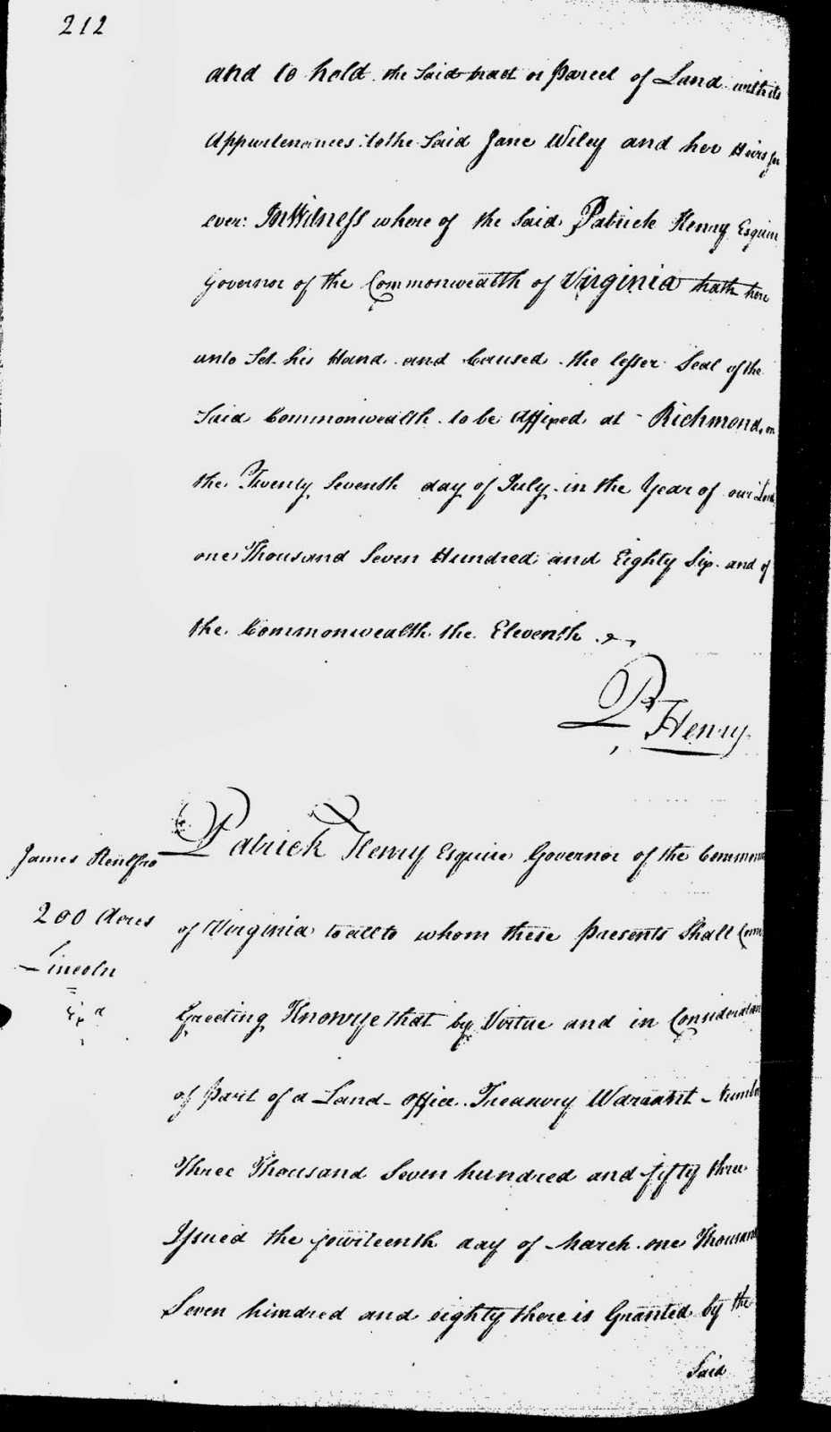
It included a land survey and on the Kentucky Land database a certificate that states it was once a grant to George Rogers Clark.


John Evan in Kentucky dug up some documents that showed Jenny Sellards Wiley and her sister Catherine Sellards Borders could read and write. They signed their names on several documents. Jenny signed her name "Jane Wiley". So is this a land grant to our Jenny Wiley before she was attacked? If it were, why would she be getting this land grant? What happened to these lands?


So you see Ladies and Gents....the true story of Jenny Wiley has just begun. I am passing this knowledge on to inspire you to continue where I can not. Jenny Wiley deserves to have her true story told.
Find the real deposition of Jenny Wiley if it exists.
William Connelly Easley's records are scattered across the midwest. I have notes on where. They should be combed for his notes to see if anything exists of his interviews of Adam Wiley.
Discover the Wiley and Sellards family tree in Chancery, court cases, marriage and land records. Where did Jenny and Catherine learn to read and write?
More research on who was the Jane Wiley of the 560 acres Kentucky land grant.
Try to identify the Indians that did this attack and understand the Native American's reason for it.
Take each part of the Jenny Wiley stories and prove or disprove whether it is true or not.
Let me know what you FIND!
One more item. I believe Thomas Stuart Walker's lands that mentions Thomas Wiley's land border, were very close to an old church that the building still exists on 61 called Nebo. That is on the Bland County side about a 1/2 mile from the Cove Road. Many years ago I researched the Thomas Walker family of Clear Fork (Distant kin to the Thomas Walker of Walker's mountain fame) and located the lands for the family. This Walker family donated lands for the church and here is a deed where his corner is at Thomas Wiley's.

I usually go over this couple of times again.... but folks....I am exhausted. The old ticker is flip flopping and I ache like a toothache. Jenny Wiley needs to be left with those who are in better health. There may be errors just contact me and point them out. I probably won't post again for at least another month or more. It will take me that much time to rest and to recover. Going to take me that much time to clean off the bed and put the books up!!
Books I recommend
"Early Adventurers on the Western Waters" Volumes by Mary B. Kegley and F.B. Kegley, Green Publishers, Inc. Orange, VA
The American Revolution in Indian Country: Crisis and Diversity in Native American communities, by Colin G. Calloway, Cambridge University Press
The Ambiguous Iroquois Empire: The Covenant Chain Confederation of Indian Tribes with English Colonies from its beginnings to the Lancaster Treaty of 1744 By Francis Jennings, W.W. Norton and Company
Stories of Jenny Wiley: Exploring the History and the Legends, by Todd Pack, 2013, Published by Story ATOM Media
No comments:
Post a Comment